Saunton Sands Surf Report
| Wave height * | 1ft / 0.3m |
|---|---|
| Swell period | 11s |
| Swell direction | |
| Wind | |
| Sea temp | 11°C / 51°F |
10 day Saunton Sands surf forecast
Tue
23/Apr
1ft
3
11
8
- Low 12:50am
- High 7:06am
- Low 1:08pm
- High 7:25pm
Wed
24/Apr
1.5ft
8
8
11
- Low 1:20am
- High 7:38am
- Low 1:36pm
- High 7:55pm
Thu
25/Apr
2ft
8
13
7
- Low 1:50am
- High 8:09am
- Low 2:05pm
- High 8:26pm
Fri
26/Apr
3ft
7
7
4
- Low 2:20am
- High 8:41am
- Low 2:34pm
- High 8:59pm
Sat
27/Apr
2.5ft
6
14
14
- Low 2:52am
- High 9:15am
- Low 3:06pm
- High 9:34pm
Sun
28/Apr
5ft
25
13
13
- Low 3:29am
- High 9:53am
- Low 3:43pm
- High 10:15pm
Mon
29/Apr
3ft
9
17
8
- Low 4:14am
- High 10:41am
- Low 4:33pm
- High 11:11pm
Tue
30/Apr
6ft
10
21
23
- Low 5:20am
- High 11:46am
- Low 5:49pm
Wed
1/May
5.5ft
10
17
10
- High 12:31am
- Low 6:53am
- High 1:15pm
- Low 7:34pm
Thu
2/May
5.5ft
8
12
7
- High 2:03am
Tue 23rd Apr
| 4:00 | 1ft | 1.5ft | 6s | 1mph (2mph) | |||
| 7:00 | 0.5ft | 1.1ft | 9s | 3mph (5mph) | |||
| 10:00 | 1ft | 1ft | 11s | 4mph (5mph) | |||
| 13:00 | 1ft | 1.3ft | 10s | 11mph (13mph) | |||
| 16:00 | 2ft | 2.1ft | 10s | 16mph (20mph) | |||
| 19:00 | 2ft | 2.8ft | 6s | 8mph (15mph) |
| Tide times |
|---|
| Low 12:50am (1.21m) |
| High 7:06am (8.74m) |
| Low 1:08pm (1.18m) |
| High 7:25pm (8.80m) |
| Daylight | |
|---|---|
| First light | 05:27 |
| Sunrise | 06:03 |
| Sunset | 20:26 |
| Dark | 21:02 |
Wed 24th Apr
| 4:00 | 2ft | 2.1ft | 9s | 9mph (15mph) | |||
| 7:00 | 2ft | 2.1ft | 9s | 8mph (13mph) | |||
| 10:00 | 1.5ft | 1.9ft | 9s | 10mph (11mph) | |||
| 13:00 | 1.5ft | 1.8ft | 9s | 8mph (7mph) | |||
| 16:00 | 1.5ft | 1.7ft | 9s | 9mph (7mph) | |||
| 19:00 | 2ft | 2ft | 10s | 11mph (11mph) |
| Tide times |
|---|
| Low 1:20am (1.13m) |
| High 7:38am (8.80m) |
| Low 1:36pm (1.16m) |
| High 7:55pm (8.83m) |
| Daylight | |
|---|---|
| First light | 05:25 |
| Sunrise | 06:01 |
| Sunset | 20:27 |
| Dark | 21:04 |
Thu 25th Apr
| 4:00 | 1.5ft | 1.8ft | 9s | 5mph (8mph) | |||
| 7:00 | 1.5ft | 1.7ft | 9s | 8mph (17mph) | |||
| 10:00 | 1.5ft | 1.9ft | 9s | 13mph (17mph) | |||
| 13:00 | 2ft | 2.2ft | 8s | 13mph (15mph) | |||
| 16:00 | 2ft | 2.5ft | 8s | 12mph (15mph) | |||
| 19:00 | 2ft | 2.3ft | 8s | 7mph (11mph) |
| Tide times |
|---|
| Low 1:50am (1.16m) |
| High 8:09am (8.75m) |
| Low 2:05pm (1.26m) |
| High 8:26pm (8.74m) |
| Daylight | |
|---|---|
| First light | 05:23 |
| Sunrise | 05:59 |
| Sunset | 20:29 |
| Dark | 21:06 |
Fri 26th Apr
| 4:00 | 2ft | 2.2ft | 6s | 9mph (13mph) | |||
| 7:00 | 2.5ft | 2.9ft | 6s | 7mph (11mph) | |||
| 10:00 | 3ft | 3.4ft | 7s | 5mph (6mph) | |||
| 13:00 | 3ft | 3.4ft | 7s | 7mph (5mph) | |||
| 16:00 | 3ft | 3.1ft | 10s | 8mph (6mph) | |||
| 19:00 | 2.5ft | 2.8ft | 10s | 4mph (6mph) |
| Tide times |
|---|
| Low 2:20am (1.31m) |
| High 8:41am (8.58m) |
| Low 2:34pm (1.48m) |
| High 8:59pm (8.52m) |
| Daylight | |
|---|---|
| First light | 05:21 |
| Sunrise | 05:58 |
| Sunset | 20:31 |
| Dark | 21:08 |
Sat 27th Apr
| 4:00 | 2.5ft | 2.7ft | 13s | 12mph (20mph) | |||
| 7:00 | 2.5ft | 2.7ft | 11s | 6mph (13mph) | |||
| 10:00 | 2.5ft | 2.8ft | 11s | 13mph (20mph) | |||
| 13:00 | 2.5ft | 2.9ft | 11s | 14mph (23mph) | |||
| 16:00 | 3ft | 3.3ft | 9s | 20mph (30mph) | |||
| 19:00 | 3ft | 3.4ft | 6s | 14mph (23mph) |
| Tide times |
|---|
| Low 2:52am (1.57m) |
| High 9:15am (8.28m) |
| Low 3:06pm (1.80m) |
| High 9:34pm (8.20m) |
| Daylight | |
|---|---|
| First light | 05:19 |
| Sunrise | 05:56 |
| Sunset | 20:32 |
| Dark | 21:09 |
Sun 28th Apr
| 4:00 | 2ft | 2.3ft | 8s | 23mph (34mph) | |||
| 7:00 | 3.5ft | 4.8ft | 5s | 25mph (36mph) | |||
| 10:00 | 4.5ft | 6ft | 7s | 24mph (30mph) | |||
| 13:00 | 5ft | 6.3ft | 8s | 13mph (20mph) | |||
| 16:00 | 5ft | 6.6ft | 8s | 18mph (23mph) | |||
| 19:00 | 4ft | 5.4ft | 7s | 13mph (19mph) |
| Tide times |
|---|
| Low 3:29am (1.92m) |
| High 9:53am (7.89m) |
| Low 3:43pm (2.20m) |
| High 10:15pm (7.80m) |
| Daylight | |
|---|---|
| First light | 05:16 |
| Sunrise | 05:54 |
| Sunset | 20:34 |
| Dark | 21:11 |
Mon 29th Apr
| 4:00 | 2ft | 2.3ft | 8s | 10mph (20mph) | |||
| 7:00 | 2.5ft | 2.8ft | 6s | 9mph (15mph) | |||
| 10:00 | 3ft | 3.2ft | 6s | 15mph (18mph) | |||
| 13:00 | 3ft | 3ft | 6s | 17mph (22mph) | |||
| 16:00 | 3ft | 3.3ft | 7s | 14mph (20mph) | |||
| 19:00 | 3.5ft | 3.7ft | 5s | 8mph (12mph) |
| Tide times |
|---|
| Low 4:14am (2.34m) |
| High 10:41am (7.43m) |
| Low 4:33pm (2.66m) |
| High 11:11pm (7.38m) |
| Daylight | |
|---|---|
| First light | 05:14 |
| Sunrise | 05:52 |
| Sunset | 20:36 |
| Dark | 21:13 |
Tue 30th Apr
| 4:00 | 4ft | 4.3ft | 6s | 8mph (15mph) | |||
| 7:00 | 5ft | 5.4ft | 7s | 10mph (19mph) | |||
| 10:00 | 5.5ft | 6ft | 7s | 16mph (21mph) | |||
| 13:00 | 6ft | 6.8ft | 8s | 21mph (27mph) | |||
| 16:00 | 7ft | 7.6ft | 8s | 24mph (40mph) | |||
| 19:00 | 8ft | 8.7ft | 9s | 23mph (38mph) |
| Tide times |
|---|
| Low 5:20am (2.74m) |
| High 11:46am (7.02m) |
| Low 5:49pm (3.05m) |
| Daylight | |
|---|---|
| First light | 05:12 |
| Sunrise | 05:50 |
| Sunset | 20:37 |
| Dark | 21:15 |
Wed 1st May
| 4:00 | 5ft | 5.7ft | 9s | 13mph (22mph) | |||
| 7:00 | 5ft | 5.6ft | 9s | 10mph (18mph) | |||
| 10:00 | 5.5ft | 5.7ft | 10s | 13mph (17mph) | |||
| 13:00 | 5.5ft | 5.8ft | 10s | 17mph (25mph) | |||
| 16:00 | 5.5ft | 5.8ft | 11s | 18mph (23mph) | |||
| 19:00 | 5.5ft | 5.7ft | 11s | 10mph (15mph) |
| Tide times |
|---|
| High 12:31am (7.13m) |
| Low 6:53am (2.87m) |
| High 1:15pm (6.90m) |
| Low 7:34pm (3.02m) |
| Daylight | |
|---|---|
| First light | 05:10 |
| Sunrise | 05:48 |
| Sunset | 20:39 |
| Dark | 21:17 |
Thu 2nd May
| 4:00 | 5.5ft | 5.7ft | 10s | 8mph (18mph) | |||
| 7:00 | 5.5ft | 5.6ft | 10s | 8mph (21mph) | |||
| 10:00 | 5.5ft | 5.7ft | 10s | 11mph (17mph) | |||
| 13:00 | 5.5ft | 5.7ft | 7s | 12mph (16mph) | |||
| 16:00 | 5ft | 5.4ft | 7s | 12mph (17mph) | |||
| 19:00 | 5ft | 5.1ft | 7s | 7mph (13mph) |
| Tide times |
|---|
| High 2:03am (7.30m) |
| Daylight | |
|---|---|
| First light | 05:08 |
| Sunrise | 05:46 |
| Sunset | 20:40 |
| Dark | 21:19 |
Nearest buoys
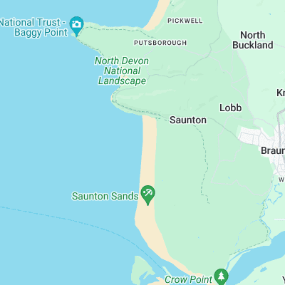
Gently shelving beach producing long,slow walls - ideal for longboarders and beginners. Bit of shelter from N winds at the north end of the beach up by 'The Cave'
Surf spots nearby
- Downend Point (1.2 mi)
- Croyde (1.5 mi)
- Putsborough (2.4 mi)
- Woolacombe (4.1 mi)
- Westward Ho! (4.4 mi)
- Combesgate (4.7 mi)
- Bucks Mill (9.8 mi)
- Clovelly (10.6 mi)
- Spekes Mill (16 mi)
- Lynmouth (19 mi)
Not Magic Seaweed (MSW)
Although we look a bit like Magic Seaweed we are not MagicSeaweed as they no longer exist...