Downend Point Surf Report
| Wave height * | 1.5ft / 0.4m |
|---|---|
| Swell period | 10s |
| Swell direction | |
| Wind | |
| Sea temp | 12°C / 53°F |
10 day Downend Point surf forecast
Sat
18/May
1.5ft
2
7
4
- High 3:03am
- Low 9:17am
- High 3:38pm
- Low 9:37pm
Sun
19/May
1ft
5
12
8
- High 3:57am
- Low 10:08am
- High 4:27pm
- Low 10:24pm
Mon
20/May
1ft
5
10
9
- High 4:42am
- Low 10:50am
- High 5:07pm
- Low 11:05pm
Tue
21/May
1ft
6
5
8
- High 5:21am
- Low 11:28am
- High 5:44pm
- Low 11:42pm
Wed
22/May
1.5ft
4
9
6
- High 5:58am
- Low 12:03pm
- High 6:20pm
Thu
23/May
3.5ft
4
5
6
- Low 12:18am
- High 6:34am
- Low 12:37pm
- High 6:55pm
Fri
24/May
5.5ft
10
14
11
- Low 12:53am
- High 7:11am
- Low 1:12pm
- High 7:32pm
Sat
25/May
6.5ft
10
18
13
- Low 1:30am
- High 7:48am
- Low 1:47pm
- High 8:09pm
Sun
26/May
5.5ft
7
10
9
- Low 2:07am
- High 8:27am
- Low 2:23pm
- High 8:48pm
Mon
27/May
5ft
11
16
14
- Low 2:47am
- High 9:08am
Sat 18th May
| 4:00 | 2ft | 2.1ft | 9s | 4mph (4mph) | |||
| 7:00 | 1.5ft | 1.8ft | 10s | 2mph (3mph) | |||
| 10:00 | 1.5ft | 1.6ft | 10s | 4mph (4mph) | |||
| 13:00 | 1.5ft | 1.4ft | 10s | 7mph (8mph) | |||
| 16:00 | 1.5ft | 1.4ft | 10s | 8mph (9mph) | |||
| 19:00 | 2ft | 1.9ft | 10s | 4mph (6mph) |
| Tide times |
|---|
| High 3:03am (7.03m) |
| Low 9:17am (2.82m) |
| High 3:38pm (7.06m) |
| Low 9:37pm (2.72m) |
| Daylight | |
|---|---|
| First light | 04:39 |
| Sunrise | 05:21 |
| Sunset | 21:05 |
| Dark | 21:47 |
Sun 19th May
| 4:00 | 1.5ft | 1.6ft | 10s | 5mph (6mph) | |||
| 7:00 | 1.5ft | 1.4ft | 9s | 5mph (14mph) | |||
| 10:00 | 1ft | 1.2ft | 9s | 10mph (14mph) | |||
| 13:00 | 1ft | 1.1ft | 9s | 12mph (15mph) | |||
| 16:00 | 1ft | 1.1ft | 9s | 10mph (12mph) | |||
| 19:00 | 1ft | 1.1ft | 9s | 8mph (13mph) |
| Tide times |
|---|
| High 3:57am (7.39m) |
| Low 10:08am (2.44m) |
| High 4:27pm (7.48m) |
| Low 10:24pm (2.32m) |
| Daylight | |
|---|---|
| First light | 04:38 |
| Sunrise | 05:20 |
| Sunset | 21:06 |
| Dark | 21:48 |
Mon 20th May
| 4:00 | 1ft | 1.2ft | 9s | 6mph (9mph) | |||
| 7:00 | 1ft | 1.2ft | 9s | 5mph (11mph) | |||
| 10:00 | 1ft | 1.3ft | 9s | 9mph (13mph) | |||
| 13:00 | 1ft | 1.1ft | 8s | 10mph (13mph) | |||
| 16:00 | 1ft | 1ft | 8s | 9mph (12mph) | |||
| 19:00 | 1ft | 1ft | 8s | 9mph (16mph) |
| Tide times |
|---|
| High 4:42am (7.73m) |
| Low 10:50am (2.09m) |
| High 5:07pm (7.86m) |
| Low 11:05pm (1.98m) |
| Daylight | |
|---|---|
| First light | 04:36 |
| Sunrise | 05:18 |
| Sunset | 21:08 |
| Dark | 21:50 |
Tue 21st May
| 4:00 | 1ft | 1.1ft | 8s | 6mph (12mph) | |||
| 7:00 | 1ft | 1.1ft | 9s | 6mph (17mph) | |||
| 10:00 | 1ft | 1.1ft | 9s | 7mph (11mph) | |||
| 13:00 | 1ft | 0.9ft | 9s | 5mph (6mph) | |||
| 16:00 | 1ft | 0.8ft | 9s | 6mph (5mph) | |||
| 19:00 | 0.5ft | 0.8ft | 11s | 8mph (9mph) |
| Tide times |
|---|
| High 5:21am (8.03m) |
| Low 11:28am (1.80m) |
| High 5:44pm (8.18m) |
| Low 11:42pm (1.70m) |
| Daylight | |
|---|---|
| First light | 04:35 |
| Sunrise | 05:17 |
| Sunset | 21:09 |
| Dark | 21:52 |
Wed 22nd May
| 4:00 | 1ft | 1.2ft | 10s | 4mph (4mph) | |||
| 7:00 | 1.5ft | 1.4ft | 9s | 4mph (6mph) | |||
| 10:00 | 1.5ft | 1.5ft | 9s | 7mph (8mph) | |||
| 13:00 | 1.5ft | 1.6ft | 9s | 9mph (10mph) | |||
| 16:00 | 1.5ft | 1.8ft | 9s | 8mph (8mph) | |||
| 19:00 | 3ft | 2.9ft | 9s | 6mph (7mph) |
| Tide times |
|---|
| High 5:58am (8.28m) |
| Low 12:03pm (1.58m) |
| High 6:20pm (8.44m) |
| Daylight | |
|---|---|
| First light | 04:33 |
| Sunrise | 05:16 |
| Sunset | 21:11 |
| Dark | 21:53 |
Thu 23rd May
| 4:00 | 4ft | 4.3ft | 8s | 5mph (4mph) | |||
| 7:00 | 4ft | 4.6ft | 7s | 4mph (5mph) | |||
| 10:00 | 4ft | 4.8ft | 7s | 4mph (5mph) | |||
| 13:00 | 3.5ft | 4.6ft | 6s | 5mph (6mph) | |||
| 16:00 | 3.5ft | 4.6ft | 6s | 8mph (10mph) | |||
| 19:00 | 3.5ft | 4.2ft | 6s | 6mph (10mph) |
| Tide times |
|---|
| Low 12:18am (1.49m) |
| High 6:34am (8.47m) |
| Low 12:37pm (1.43m) |
| High 6:55pm (8.64m) |
| Daylight | |
|---|---|
| First light | 04:32 |
| Sunrise | 05:15 |
| Sunset | 21:12 |
| Dark | 21:55 |
Fri 24th May
| 4:00 | 5ft | 5.8ft | 7s | 7mph (14mph) | |||
| 7:00 | 6ft | 6.4ft | 7s | 10mph (18mph) | |||
| 10:00 | 5.5ft | 6.4ft | 7s | 11mph (20mph) | |||
| 13:00 | 5.5ft | 5.9ft | 7s | 14mph (18mph) | |||
| 16:00 | 4.5ft | 5.1ft | 7s | 12mph (17mph) | |||
| 19:00 | 4ft | 4.4ft | 6s | 11mph (16mph) |
| Tide times |
|---|
| Low 12:53am (1.36m) |
| High 7:11am (8.59m) |
| Low 1:12pm (1.36m) |
| High 7:32pm (8.74m) |
| Daylight | |
|---|---|
| First light | 04:31 |
| Sunrise | 05:14 |
| Sunset | 21:13 |
| Dark | 21:56 |
Sat 25th May
| 4:00 | 3.5ft | 3.9ft | 6s | 9mph (17mph) | |||
| 7:00 | 4.5ft | 4.7ft | 13s | 10mph (22mph) | |||
| 10:00 | 6ft | 6.4ft | 12s | 16mph (26mph) | |||
| 13:00 | 6.5ft | 7.1ft | 12s | 18mph (32mph) | |||
| 16:00 | 6.5ft | 7.2ft | 11s | 17mph (32mph) | |||
| 19:00 | 6ft | 6.6ft | 11s | 13mph (26mph) |
| Tide times |
|---|
| Low 1:30am (1.32m) |
| High 7:48am (8.61m) |
| Low 1:47pm (1.40m) |
| High 8:09pm (8.73m) |
| Daylight | |
|---|---|
| First light | 04:29 |
| Sunrise | 05:13 |
| Sunset | 21:14 |
| Dark | 21:58 |
Sun 26th May
| 4:00 | 4.5ft | 5.2ft | 10s | 9mph (15mph) | |||
| 7:00 | 4.5ft | 5.2ft | 10s | 7mph (12mph) | |||
| 10:00 | 5ft | 5.7ft | 10s | 9mph (11mph) | |||
| 13:00 | 5.5ft | 6.4ft | 9s | 10mph (11mph) | |||
| 16:00 | 6.5ft | 7.2ft | 9s | 10mph (12mph) | |||
| 19:00 | 8ft | 8.7ft | 9s | 9mph (13mph) |
| Tide times |
|---|
| Low 2:07am (1.39m) |
| High 8:27am (8.51m) |
| Low 2:23pm (1.55m) |
| High 8:48pm (8.61m) |
| Daylight | |
|---|---|
| First light | 04:28 |
| Sunrise | 05:12 |
| Sunset | 21:16 |
| Dark | 21:59 |
Mon 27th May
| 4:00 | 7ft | 8ft | 9s | 12mph (20mph) | |||
| 7:00 | 6.5ft | 7.1ft | 9s | 11mph (18mph) | |||
| 10:00 | 5.5ft | 6.3ft | 9s | 13mph (17mph) | |||
| 13:00 | 5ft | 5.3ft | 8s | 16mph (21mph) | |||
| 16:00 | 4ft | 4.5ft | 8s | 15mph (19mph) | |||
| 19:00 | 3.5ft | 3.9ft | 8s | 14mph (19mph) |
| Tide times |
|---|
| Low 2:47am (1.55m) |
| High 9:08am (8.31m) |
| Daylight | |
|---|---|
| First light | 04:27 |
| Sunrise | 05:11 |
| Sunset | 21:17 |
| Dark | 22:01 |
Nearest buoys
Fast shallow reef-break that can deliver a long right with hollow sections on a good day. Left can be good, but gets closey with size Getting in and out is sketchy!
There is another reef outside of Downend called Oyster Falls - North Devons big wave spot. It only breaks when there is a big swell running and has only been surfed a few times.
On bigger days it makes a good indicator spot for Downend
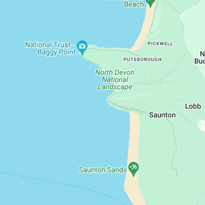
Surf spots nearby
- Croyde (0.5 mi)
- Saunton Sands (1.2 mi)
- Putsborough (1.9 mi)
- Woolacombe (3.5 mi)
- Combesgate (4 mi)
- Westward Ho! (5.3 mi)
- Bucks Mill (10.2 mi)
- Clovelly (10.7 mi)
- Spekes Mill (15.8 mi)
- Lynmouth (19.4 mi)
Not Magic Seaweed (MSW)
Although we look a bit like Magic Seaweed we are not MagicSeaweed as they no longer exist...