La Terriere Surf Report
| Wave height * | 1.5ft / 0.4m |
|---|---|
| Swell period | 9s |
| Swell direction | |
| Wind | |
| Sea temp | 13°C / 55°F |
10 day La Terriere surf forecast
Thu
25/Apr
1.5ft
8
1
13
- Low 12:51am
- High 6:28am
- Low 1:07pm
- High 6:39pm
Fri
26/Apr
1.5ft
8
10
6
- Low 1:26am
- High 6:54am
- Low 1:43pm
- High 7:04pm
Sat
27/Apr
4ft
20
30
23
- Low 2:05am
- High 7:22am
- Low 2:23pm
- High 7:34pm
Sun
28/Apr
4.5ft
23
19
11
- Low 2:49am
- High 7:56am
- Low 3:09pm
- High 8:12pm
Mon
29/Apr
1.5ft
7
2
13
- Low 3:40am
- High 8:43am
- Low 4:04pm
- High 9:08pm
Tue
30/Apr
1.5ft
5
7
12
- Low 4:40am
- High 12:02pm
- Low 5:08pm
Wed
1/May
3ft
10
3
3
- High 12:29am
- Low 5:50am
- High 1:26pm
- Low 6:21pm
Thu
2/May
4ft
23
12
8
- High 1:45am
- Low 7:06am
- High 2:26pm
- Low 7:35pm
Fri
3/May
4.5ft
17
15
18
- High 2:42am
- Low 8:15am
- High 3:15pm
- Low 8:41pm
Sat
4/May
3ft
18
16
14
- High 3:31am
- Low 9:15am
- High 3:59pm
- Low 9:37pm
Thu 25th Apr
| 5:00 | 1.5ft | 2.4ft | 8s | 10mph (12mph) | |||
| 8:00 | 2ft | 2.2ft | 10s | 8mph (9mph) | |||
| 11:00 | 1.5ft | 1.9ft | 9s | 6mph (6mph) | |||
| 14:00 | 1.5ft | 1.7ft | 9s | 1mph (2mph) | |||
| 17:00 | 1.5ft | 1.6ft | 9s | 7mph (9mph) | |||
| 20:00 | 1.5ft | 1.8ft | 9s | 13mph (14mph) |
| Tide times |
|---|
| Low 12:51am (1.41m) |
| High 6:28am (5.70m) |
| Low 1:07pm (1.52m) |
| High 6:39pm (5.70m) |
| Daylight | |
|---|---|
| First light | 06:26 |
| Sunrise | 06:58 |
| Sunset | 21:08 |
| Dark | 21:41 |
Fri 26th Apr
| 5:00 | 1.5ft | 1.7ft | 8s | 11mph (12mph) | |||
| 8:00 | 1.5ft | 1.6ft | 8s | 8mph (9mph) | |||
| 11:00 | 1.5ft | 1.6ft | 8s | 8mph (9mph) | |||
| 14:00 | 1.5ft | 1.6ft | 6s | 10mph (11mph) | |||
| 17:00 | 1.5ft | 2ft | 5s | 9mph (10mph) | |||
| 20:00 | 2ft | 2.5ft | 9s | 6mph (7mph) |
| Tide times |
|---|
| Low 1:26am (1.50m) |
| High 6:54am (5.54m) |
| Low 1:43pm (1.67m) |
| High 7:04pm (5.57m) |
| Daylight | |
|---|---|
| First light | 06:24 |
| Sunrise | 06:57 |
| Sunset | 21:09 |
| Dark | 21:42 |
Sat 27th Apr
| 5:00 | 2.5ft | 3.3ft | 10s | 17mph (26mph) | |||
| 8:00 | 3ft | 3.7ft | 10s | 20mph (28mph) | |||
| 11:00 | 3ft | 4ft | 10s | 22mph (31mph) | |||
| 14:00 | 4ft | 4.6ft | 8s | 30mph (39mph) | |||
| 17:00 | 3.5ft | 4.2ft | 13s | 22mph (32mph) | |||
| 20:00 | 3ft | 3.6ft | 13s | 23mph (29mph) |
| Tide times |
|---|
| Low 2:05am (1.64m) |
| High 7:22am (5.33m) |
| Low 2:23pm (1.87m) |
| High 7:34pm (5.39m) |
| Daylight | |
|---|---|
| First light | 06:22 |
| Sunrise | 06:55 |
| Sunset | 21:11 |
| Dark | 21:44 |
Sun 28th Apr
| 5:00 | 3ft | 4ft | 12s | 22mph (26mph) | |||
| 8:00 | 3.5ft | 4.3ft | 9s | 23mph (25mph) | |||
| 11:00 | 4.5ft | 5.4ft | 6s | 21mph (23mph) | |||
| 14:00 | 4.5ft | 5ft | 6s | 19mph (21mph) | |||
| 17:00 | 4ft | 4.2ft | 6s | 12mph (13mph) | |||
| 20:00 | 3ft | 3.5ft | 6s | 11mph (11mph) |
| Tide times |
|---|
| Low 2:49am (1.83m) |
| High 7:56am (5.08m) |
| Low 3:09pm (2.10m) |
| High 8:12pm (5.15m) |
| Daylight | |
|---|---|
| First light | 06:20 |
| Sunrise | 06:53 |
| Sunset | 21:12 |
| Dark | 21:45 |
Mon 29th Apr
| 5:00 | 2ft | 2.4ft | 10s | 6mph (5mph) | |||
| 8:00 | 1.5ft | 2.2ft | 11s | 7mph (6mph) | |||
| 11:00 | 1.5ft | 2ft | 15s | 7mph (7mph) | |||
| 14:00 | 1.5ft | 1.8ft | 13s | 2mph (1mph) | |||
| 17:00 | 1.5ft | 1.7ft | 13s | 9mph (8mph) | |||
| 20:00 | 1.5ft | 1.7ft | 13s | 13mph (12mph) |
| Tide times |
|---|
| Low 3:40am (2.05m) |
| High 8:43am (4.78m) |
| Low 4:04pm (2.33m) |
| High 9:08pm (4.88m) |
| Daylight | |
|---|---|
| First light | 06:19 |
| Sunrise | 06:52 |
| Sunset | 21:13 |
| Dark | 21:46 |
Tue 30th Apr
| 5:00 | 1.5ft | 1.5ft | 12s | 7mph (7mph) | |||
| 8:00 | 1.5ft | 1.4ft | 12s | 5mph (5mph) | |||
| 11:00 | 1.5ft | 1.4ft | 12s | 0mph (1mph) | |||
| 14:00 | 1.5ft | 1.5ft | 12s | 7mph (9mph) | |||
| 17:00 | 1.5ft | 1.9ft | 11s | 13mph (15mph) | |||
| 20:00 | 1.5ft | 2.2ft | 9s | 12mph (14mph) |
| Tide times |
|---|
| Low 4:40am (2.23m) |
| High 12:02pm (4.55m) |
| Low 5:08pm (2.47m) |
| Daylight | |
|---|---|
| First light | 06:17 |
| Sunrise | 06:50 |
| Sunset | 21:15 |
| Dark | 21:48 |
Wed 1st May
| 5:00 | 3ft | 3.5ft | 8s | 14mph (17mph) | |||
| 8:00 | 2.5ft | 3.3ft | 10s | 10mph (10mph) | |||
| 11:00 | 2.5ft | 3.3ft | 10s | 6mph (6mph) | |||
| 14:00 | 3ft | 3.3ft | 10s | 3mph (3mph) | |||
| 17:00 | 3ft | 3.4ft | 10s | 4mph (3mph) | |||
| 20:00 | 3ft | 3.6ft | 10s | 3mph (4mph) |
| Tide times |
|---|
| High 12:29am (4.80m) |
| Low 5:50am (2.28m) |
| High 1:26pm (4.76m) |
| Low 6:21pm (2.44m) |
| Daylight | |
|---|---|
| First light | 06:15 |
| Sunrise | 06:49 |
| Sunset | 21:16 |
| Dark | 21:49 |
Thu 2nd May
| 5:00 | 3.5ft | 4.1ft | 12s | 17mph (18mph) | |||
| 8:00 | 3.5ft | 4.2ft | 12s | 23mph (23mph) | |||
| 11:00 | 3.5ft | 4.4ft | 12s | 22mph (22mph) | |||
| 14:00 | 4ft | 4.8ft | 11s | 12mph (14mph) | |||
| 17:00 | 3.5ft | 4.4ft | 11s | 6mph (6mph) | |||
| 20:00 | 3.5ft | 4ft | 10s | 8mph (9mph) |
| Tide times |
|---|
| High 1:45am (5.09m) |
| Low 7:06am (2.13m) |
| High 2:26pm (5.08m) |
| Low 7:35pm (2.19m) |
| Daylight | |
|---|---|
| First light | 06:14 |
| Sunrise | 06:47 |
| Sunset | 21:17 |
| Dark | 21:51 |
Fri 3rd May
| 5:00 | 4ft | 4.9ft | 8s | 16mph (17mph) | |||
| 8:00 | 4ft | 5ft | 8s | 17mph (19mph) | |||
| 11:00 | 4ft | 5.1ft | 8s | 15mph (18mph) | |||
| 14:00 | 4.5ft | 5.5ft | 8s | 15mph (17mph) | |||
| 17:00 | 5ft | 5.9ft | 9s | 19mph (21mph) | |||
| 20:00 | 5.5ft | 6ft | 9s | 18mph (22mph) |
| Tide times |
|---|
| High 2:42am (5.44m) |
| Low 8:15am (1.81m) |
| High 3:15pm (5.41m) |
| Low 8:41pm (1.80m) |
| Daylight | |
|---|---|
| First light | 06:12 |
| Sunrise | 06:46 |
| Sunset | 21:18 |
| Dark | 21:52 |
Sat 4th May
| 5:00 | 4.5ft | 4.9ft | 8s | 17mph (23mph) | |||
| 8:00 | 3.5ft | 4.2ft | 8s | 18mph (21mph) | |||
| 11:00 | 3.5ft | 3.5ft | 8s | 18mph (20mph) | |||
| 14:00 | 3ft | 3ft | 8s | 16mph (18mph) | |||
| 17:00 | 2.5ft | 2.7ft | 7s | 18mph (20mph) | |||
| 20:00 | 2ft | 2.4ft | 7s | 14mph (18mph) |
| Tide times |
|---|
| High 3:31am (5.76m) |
| Low 9:15am (1.42m) |
| High 3:59pm (5.71m) |
| Low 9:37pm (1.37m) |
| Daylight | |
|---|---|
| First light | 06:10 |
| Sunrise | 06:44 |
| Sunset | 21:20 |
| Dark | 21:54 |
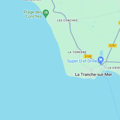
Surf spots nearby
- Le Phare du Groin du Cou (1.3 mi)
- La Tranche sur Mer (2.4 mi)
- Les Conches (2.5 mi)
- Bud Bud (3.2 mi)
- Ile de Ré - Le Lizay (7 mi)
- Ile de Ré - La Couarde (13.3 mi)
- Ile de Ré - Les Grenettes (14.7 mi)
- Tanchet (Les Sables d'Olonne) (16.1 mi)
- La Baie des Sables (17.5 mi)
- Chassiron - Ile d'Oleron (21.3 mi)
Not Magic Seaweed (MSW)
Although we look a bit like Magic Seaweed we are not MagicSeaweed as they no longer exist...