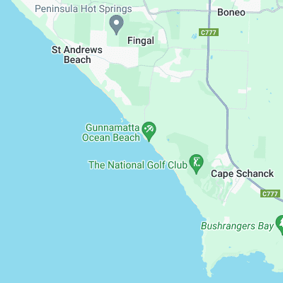
Gunnamatta Surf Report
| Wave height * | 3.5ft / 1.1m |
|---|---|
| Swell period | 13s |
| Swell direction | |
| Wind | |
| Sea temp | 17°C / 63°F |
10 day Gunnamatta surf forecast
Sun
21/Apr
4ft
11
9
10
- Low 2:06am
- High 7:58am
- Low 2:07pm
- High 8:49pm
Mon
22/Apr
4.5ft
7
9
6
- Low 3:16am
- High 9:21am
- Low 3:21pm
- High 9:47pm
Tue
23/Apr
4ft
14
16
12
- Low 4:22am
- High 10:41am
- Low 4:38pm
- High 10:42pm
Wed
24/Apr
14.5ft
28
30
25
- Low 5:17am
- High 11:45am
- Low 5:44pm
- High 11:30pm
Thu
25/Apr
7.5ft
32
27
24
- Low 6:00am
- High 12:34pm
- Low 6:36pm
Fri
26/Apr
6ft
14
10
13
- High 12:11am
- Low 6:38am
- High 1:17pm
- Low 7:20pm
Sat
27/Apr
4ft
4
3
10
- High 12:48am
- Low 7:14am
- High 1:56pm
- Low 7:59pm
Sun
28/Apr
4ft
9
10
8
- High 1:23am
- Low 7:49am
- High 2:33pm
- Low 8:35pm
Mon
29/Apr
4ft
18
12
2
- High 1:55am
- Low 8:23am
- High 3:10pm
- Low 9:10pm
Sun 21st Apr
| 4:00 | 4ft | 4.3ft | 13s | 9mph (9mph) | |||
| 7:00 | 3.5ft | 4.2ft | 13s | 11mph (9mph) | |||
| 10:00 | 3.5ft | 4.1ft | 13s | 11mph (11mph) | |||
| 13:00 | 4ft | 4.1ft | 13s | 9mph (10mph) | |||
| 16:00 | 4ft | 4.2ft | 12s | 11mph (11mph) | |||
| 19:00 | 4ft | 4.3ft | 12s | 10mph (10mph) |
| Tide times |
|---|
| Low 2:06am (0.71m) |
| High 7:58am (1.07m) |
| Low 2:07pm (0.62m) |
| High 8:49pm (1.19m) |
| Daylight | |
|---|---|
| First light | 06:25 |
| Sunrise | 06:52 |
| Sunset | 17:46 |
| Dark | 18:13 |
Mon 22nd Apr
| 4:00 | 4.5ft | 5ft | 16s | 2mph (2mph) | |||
| 7:00 | 4.5ft | 5ft | 16s | 7mph (7mph) | |||
| 10:00 | 4.5ft | 5ft | 15s | 11mph (12mph) | |||
| 13:00 | 4.5ft | 4.8ft | 14s | 9mph (12mph) | |||
| 16:00 | 4.5ft | 4.7ft | 14s | 3mph (3mph) | |||
| 19:00 | 4ft | 4.5ft | 14s | 6mph (5mph) |
| Tide times |
|---|
| Low 3:16am (0.67m) |
| High 9:21am (1.07m) |
| Low 3:21pm (0.67m) |
| High 9:47pm (1.18m) |
| Daylight | |
|---|---|
| First light | 06:26 |
| Sunrise | 06:53 |
| Sunset | 17:44 |
| Dark | 18:11 |
Tue 23rd Apr
| 4:00 | 3.5ft | 4.2ft | 14s | 14mph (17mph) | |||
| 7:00 | 3.5ft | 4.3ft | 13s | 14mph (18mph) | |||
| 10:00 | 4ft | 4.5ft | 13s | 16mph (23mph) | |||
| 13:00 | 4ft | 4.6ft | 13s | 16mph (22mph) | |||
| 16:00 | 4.5ft | 4.9ft | 15s | 13mph (17mph) | |||
| 19:00 | 5ft | 5.7ft | 18s | 12mph (16mph) |
| Tide times |
|---|
| Low 4:22am (0.61m) |
| High 10:41am (1.13m) |
| Low 4:38pm (0.69m) |
| High 10:42pm (1.20m) |
| Daylight | |
|---|---|
| First light | 06:27 |
| Sunrise | 06:54 |
| Sunset | 17:43 |
| Dark | 18:10 |
Wed 24th Apr
| 4:00 | 7ft | 7.8ft | 16s | 34mph (42mph) | |||
| 7:00 | 8ft | 9.9ft | 13s | 28mph (36mph) | |||
| 10:00 | 10.5ft | 13ft | 13s | 28mph (34mph) | |||
| 13:00 | 14.5ft | 16.8ft | 14s | 30mph (35mph) | |||
| 16:00 | 13ft | 14.8ft | 13s | 28mph (32mph) | |||
| 19:00 | 10.5ft | 12.2ft | 12s | 25mph (31mph) |
| Tide times |
|---|
| Low 5:17am (0.52m) |
| High 11:45am (1.23m) |
| Low 5:44pm (0.67m) |
| High 11:30pm (1.24m) |
| Daylight | |
|---|---|
| First light | 06:28 |
| Sunrise | 06:55 |
| Sunset | 17:42 |
| Dark | 18:09 |
Thu 25th Apr
| 4:00 | 8.5ft | 9.9ft | 12s | 33mph (38mph) | |||
| 7:00 | 9ft | 10ft | 12s | 32mph (35mph) | |||
| 10:00 | 8ft | 9.2ft | 13s | 29mph (32mph) | |||
| 13:00 | 7.5ft | 8.7ft | 13s | 27mph (29mph) | |||
| 16:00 | 8ft | 8.7ft | 12s | 26mph (28mph) | |||
| 19:00 | 8ft | 8.8ft | 12s | 24mph (25mph) |
| Tide times |
|---|
| Low 6:00am (0.43m) |
| High 12:34pm (1.34m) |
| Low 6:36pm (0.65m) |
| Daylight | |
|---|---|
| First light | 06:29 |
| Sunrise | 06:56 |
| Sunset | 17:41 |
| Dark | 18:08 |
Fri 26th Apr
| 4:00 | 7ft | 7.9ft | 14s | 15mph (16mph) | |||
| 7:00 | 7ft | 7.4ft | 14s | 14mph (15mph) | |||
| 10:00 | 6.5ft | 7.1ft | 14s | 11mph (11mph) | |||
| 13:00 | 6ft | 6.7ft | 14s | 10mph (12mph) | |||
| 16:00 | 6ft | 6.4ft | 14s | 12mph (13mph) | |||
| 19:00 | 5.5ft | 6.1ft | 14s | 13mph (13mph) |
| Tide times |
|---|
| High 12:11am (1.27m) |
| Low 6:38am (0.35m) |
| High 1:17pm (1.44m) |
| Low 7:20pm (0.64m) |
| Daylight | |
|---|---|
| First light | 06:30 |
| Sunrise | 06:57 |
| Sunset | 17:39 |
| Dark | 18:06 |
Sat 27th Apr
| 4:00 | 5ft | 5.2ft | 13s | 9mph (9mph) | |||
| 7:00 | 4.5ft | 4.9ft | 13s | 4mph (5mph) | |||
| 10:00 | 4.5ft | 4.7ft | 13s | 1mph (1mph) | |||
| 13:00 | 4ft | 4.6ft | 13s | 3mph (3mph) | |||
| 16:00 | 4ft | 4.4ft | 13s | 7mph (7mph) | |||
| 19:00 | 4ft | 4.3ft | 13s | 10mph (9mph) |
| Tide times |
|---|
| High 12:48am (1.30m) |
| Low 7:14am (0.28m) |
| High 1:56pm (1.52m) |
| Low 7:59pm (0.63m) |
| Daylight | |
|---|---|
| First light | 06:31 |
| Sunrise | 06:58 |
| Sunset | 17:38 |
| Dark | 18:05 |
Sun 28th Apr
| 4:00 | 4ft | 4.1ft | 14s | 5mph (5mph) | |||
| 7:00 | 4ft | 4.1ft | 14s | 9mph (8mph) | |||
| 10:00 | 4ft | 4.2ft | 14s | 13mph (14mph) | |||
| 13:00 | 4ft | 4.3ft | 15s | 10mph (13mph) | |||
| 16:00 | 4ft | 4.5ft | 15s | 5mph (5mph) | |||
| 19:00 | 4.5ft | 4.7ft | 15s | 8mph (8mph) |
| Tide times |
|---|
| High 1:23am (1.33m) |
| Low 7:49am (0.22m) |
| High 2:33pm (1.57m) |
| Low 8:35pm (0.64m) |
| Daylight | |
|---|---|
| First light | 06:31 |
| Sunrise | 06:59 |
| Sunset | 17:37 |
| Dark | 18:04 |
Mon 29th Apr
| 4:00 | 4.5ft | 5ft | 14s | 20mph (32mph) | |||
| 7:00 | 4.5ft | 5ft | 13s | 18mph (31mph) | |||
| 10:00 | 4.5ft | 4.8ft | 13s | 13mph (22mph) | |||
| 13:00 | 4ft | 4.6ft | 13s | 12mph (13mph) | |||
| 16:00 | 4ft | 4.4ft | 13s | 2mph (2mph) | |||
| 19:00 | 4ft | 4.3ft | 13s | 2mph (4mph) |
| Tide times |
|---|
| High 1:55am (1.34m) |
| Low 8:23am (0.17m) |
| High 3:10pm (1.59m) |
| Low 9:10pm (0.65m) |
| Daylight | |
|---|---|
| First light | 06:32 |
| Sunrise | 07:00 |
| Sunset | 17:36 |
| Dark | 18:03 |
Tue 30th Apr
| 4:00 | 5.5ft | 6.1ft | 14s | 14mph (19mph) | |||
| 7:00 | 5.5ft | 5.8ft | 14s | 17mph (18mph) | |||
| 10:00 | 5ft | 5.7ft | 14s | 18mph (21mph) |
One of the best and most popular stretches of beach in Mornington. Quality banks are held in place by reefs under the sand
Surf spots nearby
- St Andrews Beach (2.6 mi)
- Rye Ocean Beach (3.9 mi)
- Kegs (4.2 mi)
- Bushrangers bay (4.3 mi)
- Allisons (5.3 mi)
- Shorties - Blairgowrie (7.2 mi)
- Sunset (9.1 mi)
- Left and Rights (9.5 mi)
- Gunnery (9.5 mi)
- Meanos (9.7 mi)
Not Magic Seaweed (MSW)
Although we look a bit like Magic Seaweed we are not MagicSeaweed as they no longer exist...